
In this article, Peter Dudley, of Cornwall Council’s Historic Environment Service (Projects), introduces us to the rich history and archaeology of The Lizard’s moors and downlands, from the Late Neolithic and Bronze Ages up to more recent times. Read on to discover something of the history of place names, commoning practices, settlements, barrows and farming, and how these have all influenced today’s Lizard heathlands. This article has been reproduced with the permission of the Historic Environments Service (Projects) Cornwall Council.
For many people the bleak looking downs and moors of The Lizard are iconic parts of its landscape. While they are known internationally for their biodiversity and as the home of the unique Cornish heath or Erica vagans, they are also important for archaeologists and landscape historians because of the wealth of archaeological remains they contain, and as they form part of Cornwall’s unique historic landscape character. Due to their wild appearance it is easy to imagine the downs and moors simply as natural landscapes, but their character has in part been formed, and maintained, by thousands of years of human activity, principally through the grazing of livestock.
Sometimes the term ‘rough ground’ is used to describe the moors and downs as they contain a mix of rough vegetation – coarse grassland, heather, heath species, furze (gorse), bracken and willow. Until the 19th century, upland, valley and coastal rough ground were important areas of west Cornwall’s farming landscape and used as part of the rural economy. Today, it is likely that few people are aware of the history of farmers taking sheep, cattle, ponies and goats on to the rough grazing, or of householders cutting furze (gorse), turf (peat), and ferns (bracken). Such sights were once commonplace on The Lizard.
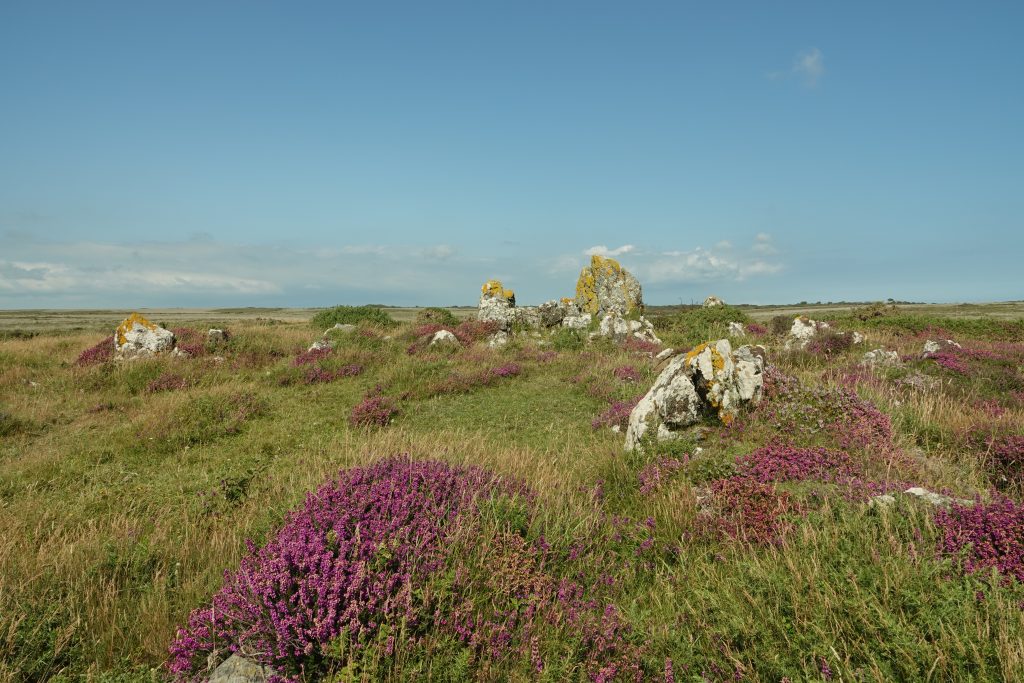
A Bronze Age barrow on Goonhilly. In the foreground is the rough vegetation of heath and coarse grassland, the barrow covered by a mix of heath and heather species (Photo © Cornwall Council).
Coastal rough ground was also once used as an important part of the agricultural economy and landscape. As with the downs and moors cliff land was used for rough grazing, the collection of domestic fuel and for the quarrying of stone. It also contains several important archaeological sites, for example the Iron Age cliff castle at Chynhalls, near Coverack (on the South West Coast Path); the promontory cut by a substantial man-made bank and ditch (Photo © Cornwall Council).
In Cornwall, areas of rough ground were commonly called in the Cornish language, goon (‘downland’), hal (‘moor’ – wet, boggy, low-lying areas) and ‘croft’ (a small enclosure of rough ground) and in English variously ‘waste’, ‘common’, ‘downs’, ‘moor’ and ‘cliff’: the place-names descriptive not only of location but of also of the mix of vegetation, land-use, ownership, and the rights (for example, grazing) that people were entitled upon them. For example, Goonhilly is a Cornish place-name that was first recorded in the mid-12th century as Goenhili. It has two possible meanings: goon- and hyli-, ‘brine’, interpreted as ‘downs of the brackish water’ (indeed, there are many pools of stagnant water on the downs), or, goon- and helghi, ‘to hunt’, ‘hunting down’.
By the 16th century Goonhilly was the largest open, unenclosed, area of rough ground in west Cornwall. It has been estimated that in the late medieval period (11th century to mid-16th century AD) about 43% of west Cornwall was rough ground, but today, through enclosure and agricultural improvement, only 11% of that total now survives.
The percentage of surviving rough ground on The Lizard is much higher as the serpentine soils prove difficult to improve and are susceptible to waterlogging. In places, these environmental conditions have favoured the formation of peat. The analysis of pollen preserved in the peat has shown that heath vegetation has been present on The Lizard from at least the Bronze Age (circa 2500BC to c. 800BC). In more exposed places heathland vegetation has probably been dominant from an earlier period, perhaps as far back as end of the last glacial period (over 10,000 years ago).
More generally it is thought that by the Late Neolithic period (c. 3000BC to c. 2500BC) people had probably started to clear woodland vegetation on quite a substantial scale, perhaps to encourage grazing by certain wild and then domesticated animals, and to help favoured plants to grow. By the Bronze Age, settlements, enclosures and ceremonial complexes were being constructed in an increasingly open landscape created and sustained by farming. At Kynance Gate, near Kynance Cove is a prehistoric settlement, first occupied in the Bronze Age.
One of the Bronze Age roundhouses at Kynance Gate, near Kynance Cove (📷 © Cornwall Council)
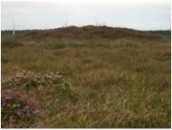
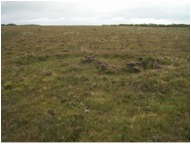
A turf stand on Goonhilly. The central platform where the turves were stacked is surrounded by a shallow ditch and an outer low bank of upcast earth material (from the digging of the ditch) (📷 © Cornwall Council)
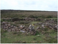
Barrows (earthen mounds) and cairns (stonier equivalents) were also built in the Bronze Age. There are many well-preserved barrows and cairns on The Lizard, such as the group at Dry Tree, near Goonhilly Earth Station. Excavated examples across Cornwall show that the internal features vary greatly. Some sites have no internal features but others contain single and multiple burials. The type of burials also vary: many contain pits with cremated ashes within urns (large pots), others have simple stone-lined cists, whilst some contain whole articulated skeletons. The larger cairns and barrows are often found in prominent positions in the landscape, for example ridges of high ground or natural rock outcrops, as if to be seen from a great distance, the other less prominent ones, it seems, used to view landscapes from.
Certainly by the medieval period, but probably from later prehistory onwards (c1000BC), the use of the rough ground was shared and divided between the tenants of farming hamlets, who had rights in ’common’ to graze their animals and to collect furze and turf for domestic fuel, cut ferns as bedding for livestock, and rushes and heather for thatching. The earlier, medieval farming settlements can be distinguished by the Cornish place-names tre-, ‘farming estate’, and bod- (bos place-names), ‘dwelling’. These settlements have their origins from between the 6th to 11th centuries AD, and are found on the fringes of the downs and moors (or the former areas of these) in the more sheltered areas and on the better soils, surrounded by field systems (often with curving, sinuous field boundaries).
From the 13th and 14th centuries onwards, the larger areas of downland were steadily subdivided into smaller blocks by Cornish hedges (stone-faced earth walls) and walls. Small enclosures of rough ground, or crofts, also began to be enclosed. By the 17th century crofts were found as part of most west Cornwall holdings, often used for grazing and/or as fuel grounds and the cutting of furze.
Up until the late 19th century furze, heath, ferns (bracken), rushes and willow were for many people still important resources, necessary for everyday life. Furze and heath were cut for the hearth (fire) to cook and to keep warm, heather and rushes harvested to provide shelter by thatching buildings, mows and ricks, ferns scythed for bedding the animals (and to produce manure) and willow to weave baskets.
Furze continued to be used as a fuel on more isolated farms into the mid 20th century, and its harvest would have once been an important event in the calendar of most west Cornwall holdings. Furze was cut throughout the summer and brought to a plot in the townplace (the yard next to the house) to be ricked (stacked), sometimes as late as September and October. When fuel was needed for the hearth, a small stack would be taken down from the rick using ‘furze hitches’ (small hand-held hooks).
Turf (the term peat is not used vernacularly in Cornwall) was also once an important domestic fuel, and in the medieval period, a valuable fuel source for tin smelting. The turf would be cut using a ‘piggal’ (a ‘beat-axe’ or ‘biddick’, a broad and heavy bladed mattock) or a ‘turf iron’ (a specially designed spade) depending on the quality of the turf. The turf would be cut in the late spring/early summer and ricked on the downs and moors for the remainder of the summer. To do so effectively the cut turves would be stacked carefully as a temporary rick to allow them to dry further and to be as sheltered as possible from any rain. Typically a stack would be rectangular in shape measuring approximately 3m in length and between 1m to 2m wide, around which a shallow ditch would be cut to improve drainage. In the late summer, as with the furze, the turves were transported to the townplace to be ricked leaving the ditch and small external upcast bank as the only surviving reminder on the downs of such activity. These features are known to archaeologists as turf stands and The Lizard has over 600 surviving examples, mostly on Goonhilly, Predannack and Lizard Downs.
A turf stand on Goonhilly. The central platform where the turves were stacked is surrounded by a shallow ditch and an outer low bank of upcast earth material (from the digging of the ditch) (📷 © Cornwall Council)
From the late 18th century onwards there were major changes to the value of the rough ground; the ideals of the ‘agricultural revolution’ were incompatible with the traditional farming economy; the rapidly rising population required housing through small holdings (single homesteads typically with small rectangular straight-sided fields and often with English place-names pre-fixed with ‘Mount-‘, or Biblical names or references to back-breaking labour); growing markets for food meant that existing farms expanded and new farms were created; and advances in technology enabled increasingly large areas of rough ground to be improved with greater ease.
In the 20th century, due to farm specialisation, principally in dairy farming, farmers lost the economic stimulus to graze the rough ground and the breeds of livestock capable of doing so. For example, The Lizard was once home to a small pony breed known as ‘Gunhillies’ or ‘Gunnellies’ of which in 1758 Rev William Borlase wrote, ‘they [ponies in Cornwall] are at present rather small, or but middle sized, especially in the coarser grounds; but they are so much more hardy [tough] than others, that they bring a large price, and a strong, punch and spirited horse, is with us [the Cornish] generally called a Gunhilly, from a wild downs of that name ‘stretching almost from Helston to the Lizherd [Lizard Point] anciently famous for such little horses’. The Cornish breed of cattle, which is now also sadly extinct, was also noted for its hardiness. Descriptions recorded the animal as typically small, black and short horned, and probably similar in appearance and temperament to the ancestors of the modern Welsh Black and Kerry breeds.
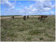
Exmoor ponies grazing on Goonhilly. This hardy breed is adapted to living on the rough ground. The ‘gunhilly’ ponies that once grazed The Lizard rough ground were probably smaller in stature, more like Shetland ponies (📷 © Cornwall Council)
Although few people now cut furze for fuel, and no one it seems has cut turf for a fuel for many years, farmers are again grazing cattle and ponies on the downs, moors and cliffs of The Lizard. Grazing is a traditional management tool and is often the best way to maintain the Lizard’s remarkable biodiversity. Importantly, for archaeologists grazing helps to keep archaeological sites visible (free from smothering scrub), and from a landscape history perspective, a welcome continuation of a farming practice with a tradition of over three thousand years.