
The history of Kennack Sands goes back a long way. Kennack is itself a mediaeval Cornish placename. The hill behind the Towans was recorded in 1510 as Carn Cunek, and the beach is recorded in 1538 as Porthkunyk. This comprises the elements of porth, meaning cove or harbour, and keun, meaning reeds or rushes. The famous botanist C. A. Johns, who spent much time exploring The Lizard, was one of the first to refer to it as Kennack Sands.
Kennack Sands is now a place for people to visit for recreation. Tourism, as for much of The Lizard, is one of the most important influences on the peninsula, alongside farming. It was not always so, of course. Fishing and the serpentine industry were important in the past, and the sea wall and other structures built during the Second World War form part of Kennack’s archaeological heritage.
 |
 |
 |
Pirates and shipwrecks
Cornwall was infamous for its piracy in earlier centuries, and The Lizard was not exempt. One real-life pirate of t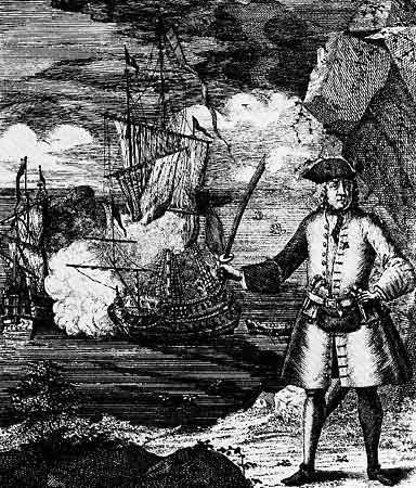 he late seventeenth century, the ‘celebrated buccaneer’ Captain John Avery, was one of the few pirates of the time to retire without ever being caught. One story tells that he hid some of his treasure at Kennack Sands. His ship was being hotly pursued by a King’s ship between Coverack and Lizard Point, and Captain Avery is reported to have sent a boat ashore carrying twelve treasure chests, full of gold and jewels. They were hidden either in a cave east of the Point, or in a cove, believed to be Kennack. Many people have searched for the treasure since, but with no success.
Kennack has its fair share of shipwrecks, like much of The Lizard. You can even spot the remains of some when the tide is particularly low.
Fishing
 One of the first things you notice about Kennack Sands is that it is divided into two main bays by a small rocky promontory: The Caerverracks. The shallow water here encouraged the use of the ground-seine net. Seine nets have been used since prehistory. They are set to hang vertically in the water with the bottom edge weighed down and the top edge buoyed up using floats. Kennack Sands fishermen set out their nets a little distance from shore by boat, and then drew the net inshore and onto land to empty out the fish. Turbot, Red Mullet, Grey Mullet, Pollack, Codling, Bass, Sole and other flatfish would regularly have been caught.
Farming

Up until the middle decades of the last century, the local farmer would let his cows out to graze the dunes. In the evening, he would call them home as he stood at his door. At that time, there was an open range policy, meaning farmers could allow cattle to graze The Towans. This kind of low-intensity farming did not damage the dunes, but kept them clear of scrub so other plants and wildlife could flourish.
The heathland beyond Gwenreath, behind Kennack Sands, used to be important as a source of domestic fuel. The low density of trees in the area available for fuel meant that locals turned instead to cutting turf and gorse (known as furze) until the late 1890s. After this, coal provided a cheaper source of fuel, transported into Cornwall by the growing rail network.
Second World War archaeology
During the Second World War, defences were built around much of the Cornish coast. The anti-tank wall, built of breezeblock infilled with concrete rubble and stones, still stands guard over the eastern beach. A similar wall used to straddle the western beach, but was removed thanks to a landfill site grant and collaboration with Cornwall Council. On the western beach, natural shore processes are once again taking hold, while on the eastern beach, the wall remains as an important piece of local archaeological interest. You can also spot a pill-box on The Towans, and tank traps at the back of the beach.
 Pillbox
Find out more about land-use and archaeology http://www.the-lizard.org/index.php/article-archives/593-the-landscape-history-and-archaeology-of-the-lizard-s-downs-and-moors on The Lizard.
If you are interested in Second World War archaeology, then you might like to explore Goonhilly Downs, to the north of Kennack Sands. We have published a walk [hyperlink to http://www.the-lizard.org/index.php/article-archives/walks/333-goonhilly-downs-a-walk-through-history] taking you through the history of Goonhilly Downs, from the arrival of prehistoric settlers to its use as a radar station in the Second World War.